
SAN JOAQUIN COUNTY, Calif. — October 29, 2026. Residents concerned about flooding, highway access and emergency evacuations along State Route 4 have two chances next week to review proposed improvements without leaving home.
The San Joaquin Council of Governments (SJCOG) and Caltrans have scheduled two virtual public workshops for Thursday, November 5, 2026. The sessions will run from 12:15 to 1 p.m. and 5:30 to 6:15 p.m., respectively. The organizers say registration is required.
Why Highway 4 flood planning matters
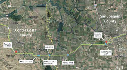
Highway 4 is an important transportation corridor through San Joaquin County. During a flood or other emergency, maintaining safe access and reliable evacuation routes can be as important as everyday mobility. The agencies are conducting a State Route 4 Flood Adaptation Strategy to understand the corridor’s exposure to flooding and identify possible ways to reduce risks.
The November 5 workshops are intended to share maps, key study findings and draft recommendations. Participants will be able to offer feedback before the strategy moves further through planning. This is a review of potential improvements, not a notice that all suggested projects have been funded or scheduled for construction.
How to participate on November 5
- Midday workshop: Thursday, November 5, from 12:15 to 1 p.m.
- Evening workshop: Thursday, November 5, from 5:30 to 6:15 p.m.
- Format: virtual meeting; advance registration required.
- Project information: SJCOG State Route 4 Flood Adaptation Strategy.
- Project questions: SR4-FAS@sjcog.org.
Caltrans lists a workshop access link in its October 28 announcement. Residents should use the official notice or SJCOG project page rather than relying on a screenshot or an unverified invitation.
What residents can raise
Useful feedback could include places where high water affects access, locations where a closed section of road would create a long detour, and routes families might need during an evacuation. People who use buses, walk, bike or provide emergency services may also have perspectives that are not obvious from vehicle traffic counts alone.
The agencies say public comments will help evaluate the draft recommendations and guide future corridor improvements. No new highway closure is announced by the workshop notice itself. For actual current road conditions, consult Caltrans QuickMap.
Source: Caltrans District 10, State Route 4 Flood Adaptation Strategy Virtual Workshops, October 28, 2026.
Support independent journalism for all Californians
Support reporting, public information and community coverage across California’s 58 counties.
Donate once by card ↗Support California58
Choose how to support California58:
Credit / Debit Card via StripeChoose an amount from $1. One-time support through the publisher's LINKERNO Stripe account.
Continue with PayPal Continue with ZelleZelle payments go to Vitaly Ataev Troshin. Please verify the recipient in your bank before sending. Availability depends on your bank.
Optional reader support. Contributions are not advertised as tax-deductible. Support does not influence editorial decisions.USEFUL SERVICES
Useful services from our ecosystem
AFFILIATED RESOURCE
Travel smarter worldwide
OptionTripAI-powered trip planning for journeys in California and around the world.
Explore OptionTrip →AFFILIATED RESOURCE
Free tax & property tools
TaxesTimeFree preliminary tax and property tools, including the Property Tax Savings Report.
Explore TaxesTime →AFFILIATED RESOURCE
California document support
LegalDocSVCDocument preparation support for self-represented Californians. Not a law firm and not legal advice.
Explore LegalDocSVC →WORK WITH CALIFORNIA58
Have a story, project or partnership idea?
California58 welcomes news tips, interviews, video projects, community partnerships, advertising and other California-focused collaborations.
Work with California58 →
COMMUNITY
Comments
Join the California58 conversation. You must be signed in to comment.
Create a free California58 account or sign in with an available social provider.